Kingdom of Tonga Concludes Participation in the Fourteenth Session of the United Nations Committee of Experts on Global Geospatial Information Management

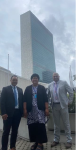
Nuku’alofa, 12 August 2024 – The Ministry of Lands, Survey, Planning, and Natural Resources is pleased to announce the successful conclusion of the Kingdom of Tonga’s participation in the Fourteenth Session of the United Nations Committee of Experts on Global Geospatial Information Management (UN-GGIM), held from 5-9 August 2024 at the United Nations Headquarters in New York.
The UN-GGIM session provided a crucial platform for Member States and relevant international organizations to engage in dialogue and cooperation on global geospatial information management. This year’s session focused on advancing the Sustainable Development Goals (SDGs) and strengthening the United Nations Integrated Geospatial Information Framework (UN-IGIF).
Tonga’s Participation and Key Contributions:
The Tonga delegation, led by Mr. Taaniela Kula, CEO of the Ministry of Lands, Survey, Planning, and Natural Resources, included Ms. Halalilika ‘Etika, Director of Lands and Geospatial Information Services Division, and Mr. Viliami Folau, Director of Surveying Services Division. The delegation actively participated in several key agenda items and forums, contributing to discussions on topics critical to Small Island Developing States (SIDS).
Key Sessions and Interventions:
Enhancing Global Geospatial Information Management Arrangements: Tonga emphasized the importance of strengthening the global geodesy supply chain to ensure the accuracy and reliability of geospatial data critical for all geospatial applications.
Integration of Geospatial Statistical and Other Related Information: Tonga highlighted the need for integrating geospatial and statistical data to address the unique challenges faced by SIDS, supporting the continued implementation of the Global Statistical Geospatial Framework (GSGF).
Integrated Marine Geospatial Information: Tonga underscored the importance of integrating terrestrial, maritime, and built domains for managing coastal zones and monitoring sea-level rise, calling for robust collaboration to implement the UN-IGIF-Hydro framework.
Policy and Legal Frameworks: The delegation emphasized the necessity of sound policy and legal frameworks to ensure geospatial data serves as a trusted resource for sustainable development, disaster resilience, and the public good.
Participation in Side Events on August 5-6, 2024:
Panel Participation on Geospatial Information for Sustainable Development and Resilience: Mr. Viliami Folau served as a panelist, sharing Tonga’s experiences and advocating for greater support and cooperation in these critical areas.
Forum on the Integration of Terrestrial Maritime and Cadastral Domains: The delegation engaged in discussions vital for exploring how integrated geospatial frameworks can be applied to support national resilience and resource management.
Outcomes and Benefits for Tonga:
Enhanced Geospatial Capabilities: The delegation engaged in knowledge exchange with international experts, gaining insights into the latest advancements and best practices in geospatial information management, which will support Tonga’s national development strategies.
Improved Coordination and Cooperation: Strengthened relationships with other Member States and international organizations will lead to improved coordination and cooperation in geospatial information management, vital for addressing global challenges and achieving the SDGs.
Access to Global Resources and Frameworks: Tonga will benefit from access to global geospatial resources and frameworks, such as the UN-IGIF, which will support the development and implementation of effective geospatial policies and initiatives in Tonga.
Capacity Building and Training: Opportunities for capacity building and training were explored during the session, enabling the development of local expertise in geospatial sciences and enhancing the overall capacity of Tonga’s geospatial information management.
Increased Resilience and Sustainability: The knowledge and frameworks gained from the session will contribute to increased resilience and sustainability in Tonga. Effective geospatial information management is crucial for disaster risk reduction, environmental conservation, and sustainable development.
The Ministry would like to acknowledge the support from the Permanent Mission of the Kingdom of Tonga to the United Nations, led by His Excellency Ambassador Va’inga Tone and Second Secretary Ms. Darlene Vaea, for their invaluable support contributing to the success of the engagement with UNGGIM.
The Kingdom of Tonga remains committed to leveraging geospatial information for sustainable development and resilience. The participation in the Fourteenth Session of UN-GGIM highlights Tonga’s dedication to enhancing its geospatial capabilities and integrating these resources into its national development strategies.
For more information, please contact: Ministry of Lands, Survey, Planning, and Natural Resources, Government of the Kingdom of Tonga,
Phone: +676 20000, Email: info@lands.gov.to, Website: www.lands.gov.to